


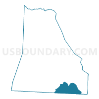
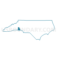
Voting District GROVER, Cleveland County, North Carolina
About
Outline

Summary
| Unique Area Identifier | 639705 |
| Name | Voting District GROVER |
| County | Cleveland County |
| State | North Carolina |
| Area (square miles) | 21.52 |
| Land Area (square miles) | 21.48 |
| Water Area (square miles) | 0.04 |
| % of Land Area | 99.82 |
| % of Water Area | 0.18 |
| Latitude of the Internal Point | 35.18463660 |
| Longtitude of the Internal Point | -81.43559320 |
Maps

Graphs
Select a template below for downloading or customizing gragh for Voting District GROVER, Cleveland County, North Carolina


Neighbors
Neighoring Voting District (by Name) Neighboring Voting District on the Map
- Antioch and King's Creek Voting District, Cherokee County, SC
- Bethany Voting District, York County, SC
- Voting District BETHWR, Cleveland County, NC
- Holly Grove and Buffalo Voting District, Cherokee County, SC
- Voting District KM3, Cleveland County, NC
- Voting District KM4, Cleveland County, NC
- Voting District RIPPY, Cleveland County, NC
Top 10 Neighboring County Subdivision (by Population) Neighboring County Subdivision on the Map
- Cleveland, Cleveland County, NC (98,078)
- Clover CCD, York County, SC (32,305)
- Blacksburg CCD, Cherokee County, SC (9,653)
Top 10 Neighboring Place (by Population) Neighboring Place on the Map
Top 10 Neighboring Unified School District (by Population) Neighboring Unified School District on the Map
- Cleveland County Schools, NC (98,078)
- Cherokee County School District, SC (53,383)
- York School District 2, SC (34,368)
Top 10 Neighboring State Legislative District Lower Chamber (by Population) Neighboring State Legislative District Lower Chamber on the Map
- State House District 111, NC (68,632)
- State House District 30, SC (34,013)
- State House District 29, SC (32,990)
Top 10 Neighboring State Legislative District Upper Chamber (by Population) Neighboring State Legislative District Upper Chamber on the Map
Top 10 Neighboring 111th Congressional District (by Population) Neighboring 111th Congressional District on the Map
Top 10 Neighboring Census Tract (by Population) Neighboring Census Tract on the Map
- Census Tract 9504, Cleveland County, NC (6,877)
- Census Tract 9506.02, Cleveland County, NC (6,014)
- Census Tract 9704.02, Cherokee County, SC (6,007)
- Census Tract 9516.02, Cleveland County, NC (4,821)
- Census Tract 617.01, York County, SC (4,395)
- Census Tract 9516.01, Cleveland County, NC (4,391)
- Census Tract 9506.01, Cleveland County, NC (3,918)
- Census Tract 9704.01, Cherokee County, SC (3,646)
- Census Tract 9505, Cleveland County, NC (3,606)